

Loading panorama viewer ...
Configuring ...
© 2004 Birger Borgwardt, All Rights Reserved.
Caption
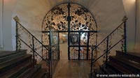
In the year 1686, the Danish Knight, Hans Friis of Clausholm Castle, build a Hospital, school and a little Church, in a town called Hoerning, in which He is buried in this crypt, together with his 3 wives, 2 sons and 2 daughters.Today the Church is still in use, and the little Hospital is a form of sanctuary, for the old people in the village.
Equipment
Nikon,Sigma 8mm, PTMac, VRHotwires, MD.
 Tap or click the zoom icon in the bottom right corner of the picture to switch between in-page and fullscreen view