

Loading panorama viewer ...
Configuring ...
© 2005 Piotr Popik, All Rights Reserved.
Caption
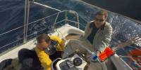
Sailing is fun, and sailing with friends on a warm, early Fall sea is even more fun. It took us one week from Split to Dubrovnik and back (268 nautical miles ~496 km). Taking this panorama was a funny thing too, but also a challenge. Since the yacht moves in all directions, stitching is a bit difficult, but doable.
This particular project was inspired by Denis Gliksman's Vendée Globe the famous Yacht Race around the world.
Thanks for the inspiration!
Equipment
The panorama was taken with
Peleng MC f 3.5/8 mm lens (set at f 8, ~ 1 m) on Canon EOS 20D camera, (set at 1/350-1/1500s, ISO 100). The panorama was stitched with 5 images (4 around plus nadir) using Professor’s Helmut Dersch Panorama Tools (PTGui 4.1 graphical interface). Autopano, Enblend and Erik's Krause "Contrast Optimization 16 bit v1.3" PS action, as well as Gimp's ability to create Text Circle Logo were all of great help. I used 16 bit source images. Equi-rectangular image was converted to QT with free version of Pano2QTVR. Thanks to all these people for the magnificent free software!
 Tap or click the zoom icon in the bottom right corner of the picture to switch between in-page and fullscreen view