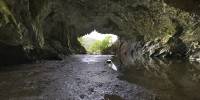

Rydal Cave
Rydal Water, Cumbria, England, UK
September 27th 2005, 15:35 British Summer Time

Loading panorama viewer ...
Configuring ...
© 2005 Steve Pendleton, All Rights Reserved.
Caption
Like a giant open mouth in the fells around Rydal Water in the English Lake District National Park, Rydal Cave is a large cavern that was created by the quarrying of the area's famous green slate. It is now a very popular stopping point for walkers and is occasionally used for concerts, offering the performers a unique location and acoustics.For me, the panorama represented a real challenge. To record the full range of the scene required bracketed exposures which were stitched as three complete files. These were then hand-blended in Photoshop to produce the final image.
This was the first time I had tried anything like this and was definitely one of those instances when one leaves a location not fully certain if everything had worked as intended, but proves very satisfying when viewing the finished image!
For a photograph of Rydal Water with the cave's location clearly visible, click here:
http://www.geograph.org.uk/photo/70597
More fullscreen panoramas at: http://www.fullscreenpanoramas.co.uk
Location
Lat: 54° 26' 36" N
Long: 3° 60' 43" W
Elevation: 285 Feet
Precision is: Unknown / Undeclared.
Equipment
Canon EOS 300D and Sigma 8mm Fisheye. Kaidan Kiwi-L pano head, Manfrotto tripod. 4 images around with hand-held nadir image. Shot Raw, converted in Adobe Camera Raw to 16 bit Tiff. Stitched in PTMac to equirectangular image, cube faces created in CubicConverter. Nadir patched into bottom cube face in Photoshop and final movies then created in CubicConverter.
 Tap or click the zoom icon in the bottom right corner of the picture to switch between in-page and fullscreen view