

Loading panorama viewer ...
Configuring ...
© 2007 Ken Stuart, All Rights Reserved.
Caption
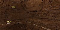
If you study archaeology in Iceland you need to know about tephra layers, shown labelled with dates (A.D.) in this panorama, which illustrates a 1-meter-square hole in the ground.Volcanic eruptions produce distinctive layers of ash (tephra) that serve to date archaeological sites extremely well, especially in Iceland as shown here. Tephra varies by color, chemical composition, and - for the trained tongue - taste. In order to determine the age of different Icelandic Viking Age sites, test pits like this one are often used to check the relationship between tephra and buried cultural deposits.
Although someone not familiar with Icelandic archaeology may see little of interest in this panorama, it does nicely illustrate various deposits of interest in this Viking Age farm site - much better than is possible with still images.
The horizontal scratchings on the walls of this pit were made by trowel-wielding archaeologists to mark different cultural deposits within this site. After this panorama was shot, students extracted soil samples from various layers for research on pH levels and botanical remains, all of which may help in knowing more about the site and its relative importance in the landscape and society at the time.
For additional panoramas of archaeology in northern Iceland, and of the town and natural scenery nearby, see the link below.
Skagafjord Archaeology and Related Panoramas and photos
Skagafjordur Archaeological Settlement Survey home page
Skagafjordur Archaeological Settlement Survey home page
Equipment
Nikon D70 with 10.5mm lens. Stitched with PTGui for Macintosh, converted to QTVR with CubicConverter. GPS location recorded with Garmin GPSmap 60CSx.
 Tap or click the zoom icon in the bottom right corner of the picture to switch between in-page and fullscreen view