

Loading panorama viewer ...
Configuring ...
© 2007 Pat Rooney, All Rights Reserved.
Caption
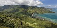
One of the more dangerous and most scenic trails on O‘ahu, Manamana trail makes a short but steep accent above the town of Ka‘a‘awa. Kahana Valley State Park contains many similar ridges and valleys, a true jewel of the island.
Check here for more panos by Pat.
Location
Lat: 21° 33' 7.31" N
Long: 158° 52' 41.09" W
Elevation: 400 meters, 1300 feet
Precision is: Medium. Nearby, but not to the last decimal.
Equipment
Canon Rebel, Canon 10-22mm, Nodal Ninga 3.
 Tap or click the zoom icon in the bottom right corner of the picture to switch between in-page and fullscreen view