
Getting Ready to Ski Lacrosse Mountain
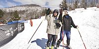
Mt. Lacrosse Ski Area, LaCrosse, Wisconsin, USA
March 3, 2007, 3pm

Loading panorama viewer ...
Configuring ...
© 2007 Richard C. Drew, All Rights Reserved.
Caption
Two ski racers make plans to do the moguls at Mt. Lacrosse. Shot at the base of the main run, near the lodge. Since I've become better on the slopes, I carry my DSLR and tripod on the hill. Before I was wary of destroying my equipment when I took some hearty tumbles downhill, ran into trees, and basically tried to kill myself while shooting at ballistic speeds downhill!
Location
Lat: 43° 44' 30.6" N
Long: 92° 11' 53.18" W
Elevation: 600
Precision is: Medium. Nearby, but not to the last decimal.
Equipment
Hardware: Canon 20D, Sigma Fisheye, Mrotator TCP short pano head, manfrotto tripod.Software: PTGui, Photoshop CS2, Pano2QTVR.
 Tap or click the zoom icon in the bottom right corner of the picture to switch between in-page and fullscreen view