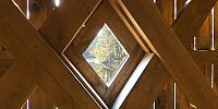

Inside Schofield Ford Covered Bridge
Tyler State Park, Newtown, Pennsylvania, USA
November 8, 2007 - 09:57 local time

Loading panorama viewer ...
Configuring ...
© 2007 Tom Fulmer, All Rights Reserved.
Caption
I chose this panorama as my Best of 2007 because of the striking combination of lines, light, and shadows. I was fortunate enough to be there at the right time to capture it. I hope you enjoy viewing it.Schofield Ford covered bridge was originally built in 1874. The bridge burned down due to arson on October 7, 1991, but was rebuilt and reopened in 1997.
Equipment
Nikon D70s, Nikkor 10.5mm 1:2.8, ISO 200, f8 1/4sec, RAW,
Adobe Bridge, Photoshop, PTGui, CubicConverter.
 Tap or click the zoom icon in the bottom right corner of the picture to switch between in-page and fullscreen view