
Storm Season on MacKenzie Beach
Vancouver Island, British Columbia, Canada
January 2, 2008, 17:15 UTC (09:15 local time)

Loading panorama viewer ...
Configuring ...
© 2008 Bob Bright, All Rights Reserved.
Caption
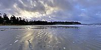
The west coast of Vancouver Island has become a favorite destination for winter storm watchers. We were fortunate to celebrate the new year at MacKenzie Beach last year with close friends, and enjoyed some truly spectacular storms as well as plenty of fine beach-combing weather.I shot this panorama on January 2nd about an hour after sunrise. It's one of my favorites of 2008, not only because of the beautiful light and reflections off the sand, but because the unsettled sky and lingering waves remind me of the previous night's storm, and of a much bigger storm to come the following day.
This is one of a series of four panoramas I shot that morning. The others can be viewed here.
BBB
More MacKenzie Beach panoramas: http://VictoriaVR.ca/immersive-panoramas/MacKenzie Beach/
Location
USA-Canada / Canada-British Columbia
Lat: 49° 7' 48.65" N
Long: 126° 55' 12.96" W
Precision is: High. Pinpoints the exact spot.
Equipment
Canon RebelXT, Tokina 10-17mm fisheye, Nodal Ninja 3, Benro carbon-fibre tripod
 Tap or click the zoom icon in the bottom right corner of the picture to switch between in-page and fullscreen view