

Loading panorama viewer ...
Configuring ...
© 2008 Jean Berthélémé, All Rights Reserved.
Caption
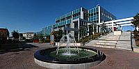
This interactive QTVR panoramic image gives a central view of Place 1604. The shiny building is Dieppe's city hall, to the left of the fountain is the old city hall, as you turn to the right, the next large building (200 Champlain Street) hosts a bank, a restaurant, a government services outlet, a café and other professional offices. Place 1604 is named in honour of the year French explorers first settled in North America. They were later called Acadians. They established a presence on a small island on the St. Croix River, between what is today the province of New Brunswick and the State of Maine. The following year, a larger permanent settlement was established in Port Royal, in today’s Nova Scotia province. In 1730, the first Acadian settlers arrived in the area of what is now Dieppe.
Today, the City of Dieppe is the 4th largest city in New Brunswick. It was formed out of the many smaller parishes and villages such as Léger's Corner, Lakeburn, Saint-Anselme, Fox Creek, Dover, and Chartersville. Its population numbers over 18,000 people and is composed of approximately 75% Francophone and 25% Anglophone.
Place 1604 is at the heart of the City of Dieppe’s effort to create a downtown area where citizens can go to eat, shop, do business, obtain government services and be entertained. Place 1604 is a bustling area any time of the year. The Dieppe Farmers’ Market is nearby, so is the Dieppe Public Library, an art gallery, an auditorium During the summer months, live entertainment is offered in the open area of Place 1604.
For more information about the City of Dieppe, see their web site at http://www.dieppe.ca
Web site: http://www3.nbnet.nb.ca/jeanbert/
Location
USA-Canada / Canada-New Brunswick
Lat: 46° 5' 41.87" N
Long: 65° 45' 55.5" W
Precision is: Medium. Nearby, but not to the last decimal.
Equipment
I used a 12 mm lens on a digital SLR camera rotated on a custom-made panoramic head placed on a tripod. Ten vertical images were captured in RAW format, colour-corrected, converted to TIF format, stitched, sharpened and saved as a very large image (12,330 x 2,911 pixels or 35.8 megapixels). The cobblestones around the fountain needed a lot of retouching to eliminate some of the water splashes from the fountain and the discoloration of a number of stones. The dark shadows caused by the low position of the sun were lightened a bit. The TIF file was then converted to a QTVR showing almost 90(v) by a full 360(h) degrees.
 Tap or click the zoom icon in the bottom right corner of the picture to switch between in-page and fullscreen view