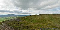

Tap O'Noth Hill Fort
Rhynie, Aberdeenshire, Scotland, UK
July 30, 2008, 13:07 BST

Loading panorama viewer ...
Configuring ...
© 2008 John McKenzie McIntosh, All Rights Reserved.
Caption
The Tap O’Noth is a conspicuous hill above Rhynie in Aberdeenshire, crowned by a hill fort with vitrified stone walls. The hill fort is the second highest in Scotland. It has grand views over the surrounding countryside which is rich in archeology including hill forts, also at Dunideer, Stone Circles at Dunideer, Ardlair (see previous entry for Elevation), Wheddlemont, Upper Ord, Corrstone Wood and Mill of Noth all in the shadow of the Tap O’Noth. Pictish carved stones are also prevalent in the area.
Location
Lat: 57° 21' 4.53" N
Long: 3° 52' 32.91" W
Precision is: Medium. Nearby, but not to the last decimal.
Equipment
Nikon D200, Nikon 12-24mm, Manfrotto 302 Panoramic Head, Manfrotto 190MF3 Tripod, QTVRAS
 Tap or click the zoom icon in the bottom right corner of the picture to switch between in-page and fullscreen view