
The Tragedy of Exercise Tiger
Slapton Sands, South Devon, England, UK
August 8, 2008, 8:53 UTC (9:53 local time)

Loading panorama viewer ...
Configuring ...
© 2008 Robert Bilsland, All Rights Reserved.
Caption
During the early hours of the April 28, 1944, eight Landing Ship Tanks full of American servicemen were taking part in Exercise Tiger, a full-scale rehearsal for the D-Day invasion of Normandy. That same evening a group of nine German E-boats set out on a normal reconnaissance mission from their base in Cherbourg, France, into the Lyme Bay area of the English coast.As the ships were approaching Lyme Bay, the E-boats made contact with them and hit three of the eight with torpedoes. Of the three hit, the first burst into flames and after 45 minutes of attempting to fight the fire, those still alive were ordered to abandon ship. The second also burst into flames but rolled over and sank within six minutes. The third was able to limp back to port but unfortunately with casualties. Many servicemen died that night; being killed in the initial attacks, in the subsequent fires, being trapped inside the sinking ships or attempting to get back to dry land. By the end of the incident over 700 people had died.
As a result of official embarrassment and concerns over possible leaks just prior to the real invasion, all survivors were sworn to secrecy, so much so that the truth of what happened wasn't officially acknowledged by the US and British armies until 40 years later.
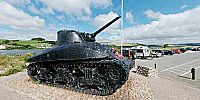
What you see here is the memorial to all those who lost their lives that night, the main feature being a recovered Sherman tank. As you can see, the time at the bottom of the sea hasn't been kind to the tank and even though it has been given a fresh coat of black paint, the the metalwork is heavily pitted.
Exercise Tiger: The Slapton Sands Sherman Tank Memorial Website
Exercise Tiger - Wikipedia
Exercise Tiger, a disaster of WW2 - what did happen?
Slapton Community Website, Operation Tiger
Exercise Tiger - Wikipedia
Exercise Tiger, a disaster of WW2 - what did happen?
Slapton Community Website, Operation Tiger
Location
Lat: 50° 16' 7.23" N
Long: 4° 40' 8.62" W
Elevation: 3 ft
Precision is: High. Pinpoints the exact spot.
Equipment
Taken with a Nikon D300 and a Nikkor 10.5mm f/2.8G fisheye lens. Mounted on a Nodal Ninja 5 Lite panorama head atop a Manfrotto 055XPROB tripod. Shots taken at 6 positions 60° apart, tilted 15° down and another shot taken looking straight up. Raw files then processed in Nikon CaptureNX 1.3 before being stitched together using PTGui Pro 8.1 beta 1 / Smartblend 1.2.5 and converted to a QTVR Cube using Pano2VR 2.2 beta 4.
 Tap or click the zoom icon in the bottom right corner of the picture to switch between in-page and fullscreen view