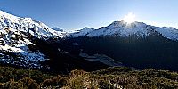

View Across Matukituki Valley to Mount Aspiring/Tititea
Mount Aspiring National Park, Otago, South Island, New Zealand / Aotearoa
August 29, 2008, 9:35 am–9:48 am local time

© 2008 Simon Wheaton, All Rights Reserved.
Mount Aspiring National Park, Otago, South Island, New Zealand/Aotearoa
This is the view across the West Matukituki Valley to Mount Aspiring (3,033 metres/9,950 feet), the third highest mountain in New Zealand, which is also known by the Maori name Tititea.
Across the valley, just to the left of the Sun poking over the ridgeline, is Rob Roy Peak. Further left, the triangular peak at the rear, is Mount Aspiring.
Mount Aspiring is a popular destination for mountain climbers. In 1949 the New Zealand Alpine Club (NZAC) built the stone Aspiring Hut, in the clearing at the base of the valley wall below this location, as a base for mountaineering in the area. Other mountain huts in this area include French Ridge Hut, across the valley and along the valley wall to the left, in front of Mount Aspiring, and Liverpool Hut, on the same side of the valley as this location, further along the valley wall to the left.
The Matukituki Valley is about an hour's drive West from Wanaka. It is a 9 kilometre (5.6 mile) hike-in from the car park at Raspberry Creek to Aspiring Hut, which takes about two and a half hours, then it is another hour or two hiking up the side of the valley, through mixed beech forest, to reach this location.
The Raspberry Creek car park is at the right hand end of the valley floor, nearly as far to the right along the valley floor as you can see in this panorama. The walking track follows the Matukituki River West Branch, past Aspiring Hut which is on the edge of the clearing at the base of the valley wall below this location, next to Cascade Creek, and continues further up the valley towards Mount Aspiring.
This panorama was shot just above the treeline/snowline on the Cascade Saddle route, which climbs steeply up the valley walls through thick beech forest, before continuing up and over the ridgeline and down to Cascade Saddle, and then further on to the Dart Glacier, River, and Hut, on the Rees-Dart track.
My plan was to climb up and over the ridgeline above my position in this panorama, and down to Cascade Saddle to shoot the panorama from there. Unfortunately, as I was shooting this panorama, clouds were slowly rolling in over the ridgeline above me, so I decided against continuing up to Cascade Saddle as I had planned, and I settled on this position to shoot the panorama from. There was also the risk of avalanche on the snow covered slopes above me, and I was by myself, so no one was around to dig me out if I was buried by an avalanche.
On my way out of the valley, a couple of hours after shooting this panorama, I noticed that the clouds up on the ridgeline had cleared, and that I could have continued on and up to Cascade Saddle after all. I'll have to try and make it up there to shoot a panorama on my next holiday to New Zealand in 2009.
- New Zealand Department of Conservation: http://www.doc.govt.nz/
- New Zealand Alpine Club: http://www.alpineclub.org.nz/
- Mainly Tramping: http://www.mainlytramping.co.nz/
- Peace River Studios: http://www.peaceriverstudios.com/
- Acratech Inc.: http://acratech.net/
- New House Internet Services B.V. (PTGui): http://www.ptgui.com/
- Pano2QTVR: http://www.pano2qtvr.com/
Australia - New Zealand / New Zealand
Lat: 45° 30' 20" S
Long: 168° 38' 50" E
Elevation: 1240 Metres
Precision is: High. Pinpoints the exact spot.
HARDWARE
- Canon EOS 350D DIGITAL (EOS Digital Rebel XT) Camera
- Canon BG-E3 Battery Grip
- Canon RS-60E3 Remote Switch
- Canon EF-S 10-22 mm f/3.5-4.5 USM Zoom Lens
- Canon EW-83E Lens Hood
- Peace River Studios 3Sixty Panoramic Camera Mount
- Manfrotto 338 Levelling Base
- Acratech Universal Cork Top Quick Release Camera Plate
- Acratech Ultimate Ballhead Tripod Head
- Gitzo G1227MK2 Mountaineer Carbon Fiber Tripod
- Inca Hotshoe-mount Dual Spirit Level
- SanDisk Extreme III 1GB CompactFlash Memory Card
- NextoDI Nexto-CF ND-2500 60GB Portable Storage Device
- Garmin eTrex Vista C GPS Receiver
- Burton Snowboards F-Stop Camera Backpack
SOFTWARE
- Adobe Photoshop CS2 (RAW Image Conversion, Image Editing and Adjustments)
- New House Internet Services B.V. PTGui (Panorama Stitching)
- Helmut Dersch's Panotools (Panorama Stitching)
- New House Internet Services B.V. PTGui (Panorama Blending)
- Andrew Mihal's Enblend (Panorama Blending)
- Thomas Rauscher's Pano2QTVR (Blended Panorama Image to QTVR Movie Conversion)
EXPOSURE
- Panorama Type: Spherical
- Number of Images: 38 (3 rows x 12 images, 1 x zenith image, 1 x nadir image)
- Focal Length: 10mm (16mm at 35mm film equivalent)
- Aperture: f/8
- Shutter Speed: 1/500 second
- Sensor Sensitivity: ISO 100
 Tap or click the zoom icon in the bottom right corner of the picture to switch between in-page and fullscreen view