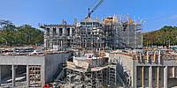

Château Louis XIV
Louveciennes, France
October 19, 2009, 14:30 UTC (12:30 local time)

Loading panorama viewer ...
Configuring ...
© 2009 Christian Braut, All Rights Reserved.
Caption
COGEMAD, a French luxury real estate developer’s latest project: the construction of a magnificent, palatial 17th Century-style château.
www.cogemad.com
www.fr-www.fr
Location
Lat: 48° 50' 59.44" N
Long: 2° 7' 13.82" E
Precision is: Medium. Nearby, but not to the last decimal.
Equipment
Taken with a Nikon ES400 mounted on a custom motorized head/12.5 meter high aerial mast system by Alticlic. Three rows of eight (horizontal + up) and six (down) shots. Optimized with Photoshop/Camera Raw, stitched with PTGui and CubicConverter.
 Tap or click the zoom icon in the bottom right corner of the picture to switch between in-page and fullscreen view