

© 2011 Caroling Geary,
Some Rights Reserved.

Here are some views into the scrub forest near the beach of the Gulf of Mexico in northwest Florida. Going counterclockwise they are:
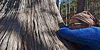
Pond Cypress tree with a base big enough to lean on (see woman in blue sweater).
Econfina Creek (see kayak).
Young Longleaf Pine tree after a controlled burn. The long needles are toasted but the growing tip is probably still green and alive within. Forests are regularly burned to simulate natural lightning fires, which keep the forest healthy.
Young Longleaf Pine, green.
Under all is white sand formed from quartz crystal. I was intrigued with the bulge of something coming up. Maybe a mole or mushroom.
Between the forest and the sea are 15 rare coastal dune lakes. They are fed with runoff from the forest, springs, and sometimes open to sea water from the Gulf. Yellow tubular flowers decorate Point Washington State Forest north of Eastern Lake.
Deer lichen carpets the forest floor with two kinds: Cladina evansii (deer moss) is puffy and Cladina subtenuis (dixie lichen) forms often greener mounds.
Pitcher plants grow near wetlands. Usually identified with the showy stems that attract and keep insects. The white-topped variety are a threatened species but there are green, parrot, and other kinds.
I missed wiregrass, palmetto and live oak that are characteristic of this forest. See links below for more photos, videos and panoramas in this area.
Pond Cypress in Swamp Tromp, a video of guided tour
Econfina Creek, several trips
Longleaf pines, sand, and other features in Florida Travel section
Eastern Lake
Deer lichen
Pitcher Plants
Lat: 30° 20' 30.8" N
Long: 87° 8' 52.5" W
Precision is: Medium. Nearby, but not to the last decimal.
Camera: Sony DSC-HX9V, except the Econfina Creek kayak was taken with an iPhone 4
Software: Photoshop CS 5.1
Platform: Mac OS X version 10.7.2 on MacBook Pro 15 inch
 Tap or click the zoom icon in the bottom right corner of the picture to switch between in-page and fullscreen view