

Loading panorama viewer ...
Configuring ...
© 2011 Vladimir Popov, All Rights Reserved.
Caption
Meshchera (or Meshchyora — it should be pronounced with "yo" emphasized) is the area between the Moskva, Oka, Klyaz'ma, Kolp' and Sudogda rivers. That is, the western corner of Meshchera is located inside of Moscow's boundaries — Losiny Ostrov ("Elk Isle") in the northeast of Moscow is considered to be a part of the Meshchera Lowland and the whole area includes the eastern part of the Moscow region, the southwestern part of the Vladimir region and the northwestern part of the Ryazan' region. The name "Meshchera" is Finno-Ugric, like many local geographic names are, and it is believed that it was the name of one of the native tribes that lived here several centuries ago. During the three glacial periods (500–400, 300–250 and 220–140 thousand years ago) Meshchera was located approximately at the southern boundaries of the glaciers, and this fact influenced the creation of modern flat relief a lot: the whole area appeared to have been merged into the water for ages, the floating sand formed flat elevations where pines grow now, sinking clay particles also gathered together to keep water and to form rather wet areas — these conditions appeared to be perfect for spruces and birches.
Nowadays Meshchera is almost completely covered with forests: light and dry pine or dark and swampy spruce and birch. Meshchera is very wet in the spring and it becomes absolutely dry by the middle of summer. Have you ever heard of summer smog in Moscow? It is the result of numerous peat inflammations in Meshchera.
The other fact concerning Meshchera that should be mentioned is that it is located on the boundary of different climatic zones: on the southern banks of the Moskva and Oka rivers vast meadows with rather small patches of light birch groves spread hundreds of miles to the south. Meshchera, which is located on the northern banks of these rivers, is a part of the vast woodland that spreads hundreds of miles to the north.
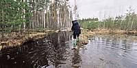
Meshchera is a great recreational area: dozens and dozens of miles of uninhabited woods — that is what is waiting for the traveler here! Our geocaching team hikes in Meshchera at least twice a year (we, Russian citizens, have convenient small holidays in the beginning of May and in the beginning of November) and during the previous decade we explored several hundreds of miles of the local sandy and swampy roads. This particular panorama was shot on May 1, 2011, in the territory of the Meshchera National Park, in the Vladimir, region during our 3-day 40-mile trip in the area between the Buzha ("u" should be emphasized) and the Pol' rivers.
Location
Lat: 55° 45' 47.7" N
Long: 40° 20' 55.74" E
Precision is: Medium. Nearby, but not to the last decimal.
Equipment
Hardware: Pentax MZ-5, MC Zenitar-K 2.8/16, no tripod.Software: ControlPoint 1.1.4, Panorama Tools, Photoshop CS, Pano2QTVR Pro 1.6.6.
 Tap or click the zoom icon in the bottom right corner of the picture to switch between in-page and fullscreen view