
Skara Brae
Bay of Skaill, Neolithic Orkney, Scotland, UK
September 12th 2012, 10:01local (9:01U)

Loading panorama viewer ...
Configuring ...
© 2012 James Gentles, All Rights Reserved.
Caption
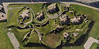
Skara Brae is the remains of a small village from 3100BC, zoom in and look around to see people's houses, and the passage-ways between them. We know virtually nothing about these people and their culture but for the tantalising glimpse of what they left behind.The abandoned remains were first unearthed in 1850 by a huge storm, then in 1925 a further storm damaged the remains and unearthed even more structures. At this time a protective sea wall was constructed and the whole site properly excavated and stabilised by archeologists.
Skara Brae is part of "Neolithic Orkney" a number of ancient monuments designated a World Heritage Site.
Location
Lat: 59° 2' 55.32" N
Long: 4° 21' 30.12" W
Elevation: 3m
Precision is: High. Pinpoints the exact spot.
Equipment
4 GoPro HERO2 cameras, with a prototype camera cradle/rig, triggered by 4
gentWIRE camera
syncronisers. Suspended below a Dan Leigh Trooper kite with 6ft/2m span.This technique produces two hemispheres, and a different workflow in PTGui from the classic ground pano technique. This results in extra effort BUT impossible angles!
See the rig, how Kite Aerial Photography is achieved, and the workflow.
 Tap or click the zoom icon in the bottom right corner of the picture to switch between in-page and fullscreen view