

© 2004 Brian Tasker, All Rights Reserved.
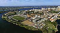
The redevelopment of 146 hectares of inner city land in East Perth, Western Australia is considered to be one of Australia's finest urban renewal projects. From what was previously a very rundown, industrialised area has sprung an exceptional model of town planning and environmental rehabilitation. The project has received numerous awards for excellence and has paved the way for similar developments Australia wide.
Australia - New Zealand / Australia
Lat: 32° 58' 5.53" S
Long: 115° 53' 5.05" E
Precision is: Medium. Nearby, but not to the last decimal.
Pentax 645 NII, 35mm lens, Kenlab KS4 Gyro, Fuji Velvia 220, Enroute Power Stitch, Photoshop CS, Apple QTVR Authoring Studio, RevolVR.
 Tap or click the zoom icon in the bottom right corner of the picture to switch between in-page and fullscreen view