
Going with the flow... Yellowstone River near Livingston Montana
Yellowstone River in the Paradise Valley, South of Livingston, Montana, USA
1:30pm Mountain Time

Loading panorama viewer ...
Configuring ...
© 2004 Craig W. Hergert, All Rights Reserved.
Caption
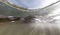
The Yellowstone River is the longest undammed river in the contiguous United States (692 miles long). Look closely, you should be able to see a few Whitefish in the water.
Equipment
Shot multi-row with Canon 10D, Sigma 24-70 and 8mm, Manfrotto 290 tri-pod, Jasper Engineering Pano-Head-and shot hand held with EWA Marine U-AXP housing. Stitched by hand in Photoshop, and using Cubic Converter and Connector for final output and sound addition. **This was my first attempt at a 360 above/underwater. Did not quite get the horizons and water to line up properly, but I think it still works. Will hopefully have a system down for next time to get a clean horizon.
 Tap or click the zoom icon in the bottom right corner of the picture to switch between in-page and fullscreen view