

Loading panorama viewer ...
Configuring ...
© 2004 David Gerhard, All Rights Reserved.
Caption
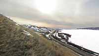
The Qu'appelle Valley is an ancient glacial meltwater spillway, now a series of mile-wide valleys in the middle of the otherwise unbroken flat prairie of Saskatchewan, Canada. Within the meandering basin flows the Qu'Appelle river, snaking back and forth from valley edge to valley edge, occasionally interrupted by valley-wide lakes. This panorama was taken an hour after sunrise, on the top of the north bank of one such lake, near Lebret, Saskatchewan.
Location
USA-Canada / Canada-Saskatchewan
Lat: 50° 45' 0" N
Long: 104° 47' 0" W
Precision is: Unknown / Undeclared.
Equipment
Nikon coolpix 4500 with FC-E8 0.21x fisheye converter. AE Lock on Panorama Assist mode. Stitched using PTMac and CubicConverter on Mac OSX.
 Tap or click the zoom icon in the bottom right corner of the picture to switch between in-page and fullscreen view