
Caracas at Sunset
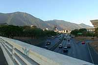
View of the Avila Mountain from Chacao, Caracas, Venezuela
6:16 pm (20:16 UTC)

Loading panorama viewer ...
Configuring ...
© 2004 Orlando Palencia, All Rights Reserved.
Caption
A view of the eastern part of the city of Caracas and its main landmark, the Cerro el Avila mountain, a National Park which stands between the town and the Caribbean Sea, as seen from the Chacao district. The highest peak reaches 2,765 mts. above sea level and the whole range covers 85,192 hectares.
Location
Lat: 10° 29' 6.74" N
Long: 67° 52' 26.51" W
Elevation: 852m
Precision is: Unknown / Undeclared.
Equipment
Six shots taken with a Nikon Coolpix 995 and FC-8 Fisheye adapter in FE2 mode, f/7.7 at 1/60 sec. Manfrotto tripod and Manfrotto 302 Plus Pano Head. Stitched with PTools on a Mac. Edited and retouched with Photoshop 6. Published as Cubic with MakeCubic and QuickTime 6.0.3 Pro
 Tap or click the zoom icon in the bottom right corner of the picture to switch between in-page and fullscreen view