
Historic Highway
At the old "Ochsenweg" (ox road) near Flensburg, Danish/German Border
March 21st 2006, 1:30 pm

Loading panorama viewer ...
Configuring ...
© 2006 Alexander Thomsen, All Rights Reserved.
Caption
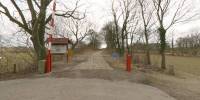
The "Ochsenweg" or "Army and Kings Road" as it was called in Denmark was the most important transit road in this region for almost 1000 years. It was about 500 Km long from Viborg (Denmark) in the north to Wedel (near Hamburg) in the south. Here you can see one of the last level barriers at a border in the EU - fortunately always open!
About a year ago I made some more panoramas in this area on the "Ochsenweg":
http://www.inshapeweb.de/dkw/Pflichtwegestein.html
http://www.inshapeweb.de/dkw/Pflichtwegestein.html
Equipment
Canon 300D, Sigma 8mm Fisheye, Manfrotto QTVR-Head, PTMac and Photoshop
Deutsch-Dänische Grenze am alten Ochsenweg
Der Ochsenweg oder Heeres und Königsweg wie dieser in Dänemark genannt wurde war die wichtigste Fernverbindung in dieser Region für fast 1000 Jahre. Er war etwa 500 km lang und führte von Viborg (Dänemark) im Norden bis nach Wedel bei Hamburg im Süden. Hier kann man einen der Letzten Schlagbäume an einer Grenze innerhalb der EU bewundern - Glücklicherweise immer geöffnet!
 Tap or click the zoom icon in the bottom right corner of the picture to switch between in-page and fullscreen view