
Antonio Victor Garcia-Serrano, PhD
At the Border of the Border
Elche (Alicante), Spain
21/03/2006 - 17:40 (GMT +1:00)

Loading panorama viewer ...
Configuring ...
© 2006 Antonio Victor Garcia-Serrano, All Rights Reserved.
Caption
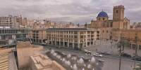
This pano was taken at the border of Altamira Palace’s north-east tower. This is a fortress that was part of the medieval city wall which dates back to the XII century.The fortress is at the north-west corner of the old citadel. It is located at the verge of the river and next to the Municipal Park. The original defensive construction has later been modified through the centuries and used for different tasks such as nobility residence, prison or even a cloth factory. Currently, it is being rehabilitated to host the new and enlarged Municipal Archaeological Museum that will be reopened this year.
The defensive wall originally surrounded about 6 hectares. Nowadays, the actual wall has almost disappeared and only unconnected parts of it still remain scattered through the city. One important such part can be seen in the pano just beside the fountain. Other important blocks of the citadel still or partially onsite are located at the Townhall, Calendura Tower and La Calahorra (see Borders WWP by Jose O´Donovan-Soler).
I would like to thank Antonio Perez Serrano (right one in the picture) for showing me around the fortress. Picture location by Sonia Zamora-Amorós. Picture production by Antonio V. Garcia-Serrano.
References:
Centro Cultural Islámico de Valencia: La palmera datilera, el árbol de la vida y Elche con su Palmeral. http://www.webcciv.org/cultura/sharq/sharq_legado_palmeradatilera_elche.htm
Gaspar Jaen i Urban et al. Guía de Arquitectura de la Provincia de Alicante - page 153. Colegio Territorial de Arquitectos de Alicante, 1999. ISBN: 84-7784-353-8
Equipment
Canon 10D - sigma 8 mm - f.11 at 1/90, iso 100, rawmanfrotto tripod and vr head
Photoshop-PTGUI-Panotools-Photoshop-Pano2QTVR
 Tap or click the zoom icon in the bottom right corner of the picture to switch between in-page and fullscreen view