
Nature Conservation "Farmer Marshland"
Burgsittensen, Niedersachsen, Germany
March 15, 2006 - 7:30am

Loading panorama viewer ...
Configuring ...
© 2006 Bernd Dohrmann, All Rights Reserved.
Caption
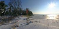
15th March 7.30 am. The temperatures are about -5° degree Celsius. Most parts of nothern Germany are heavily snow covered. This is the borderline of the nature conservation "Farmer Marshland" near Burgsittensen / Germany.The area of geological features covers an area of 1150 ha. Next to the conservation of moor landscape it is also a wildlife habitat. Domestic rare wildlife are for instance birds like teals and cranes. The marshland is dominated by acid grassland with bracken, cotton grass and rushes.
One of the most spectacular scenes within the year is the return of the cranes from their wintering grounds. Each autumn and spring the "Farmer Marshland" gives them a host on their journey.
Location
Lat: 53° 16' 11" N
Long: 9° 34' 14" E
Elevation: 112
Precision is: High. Pinpoints the exact spot.
Equipment
2x5 singelshots (2 different exposure times for each photo) on a selfmade nodalpointadapter and 1 shot freehand to the bottom (NADIR) for patching the tripod off.Hardware: Canon 300D with Sigma 8mm lens, selfmade nodalpointadapter, tripod
Software: PanoTools, PtGui4, PhotoShop6, Photomatix & pano2qtvr
 Tap or click the zoom icon in the bottom right corner of the picture to switch between in-page and fullscreen view