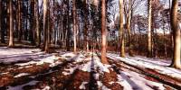

Wienerwald - Green Border of Vienna
Between Eichgraben and Rekawinkel, Austria
March 20, 2006 - 15::55 MET

Loading panorama viewer ...
Configuring ...
© 2006 Clemens Pfeiffer,
Some Rights Reserved.

Caption
The Wienerwald has probably been populated since the 8th century. Under the influence of the Avars, a Slavic population settled here after the Völkerwanderung, which may account for village names such as Döbling, Liesing or Gablitz. The Wienerwald was a princely hunting ground, but beginning with the 16th century, it gained importance also for forestry. From 1840 onwards, the industrial development encouraged increased settlement of the area. In 1870, plans were brought forward to mostly clear the forest, but this caused widespread public resistance, in which Josef Schöffel was one of the most important figures.In 1987, the governors of the states of Vienna, Lower Austria and Burgenland signed the so-called Wienerwald declaration to protect nature in the region.
from: www.wikipedia.org
- English Wikipedia http://en.wikipedia.org/wiki/Wienerwald
- German Wikipedia http://de.wikipedia.org/wiki/Wienerwald
Equipment
E4500, Stitcher 5.1
 Tap or click the zoom icon in the bottom right corner of the picture to switch between in-page and fullscreen view