
The City of Thunder Bay versus The Fort William First Nations
Thunder Bay, Ontario, Canada
Monday, March 20, 5:19 PM

Loading panorama viewer ...
Configuring ...
© 2006 F. Sean Bickford, All Rights Reserved.
Caption
Fort William Indian Reserve No. 52 was established in 1850 with a total area of 19,200 acres. Over the years, land was transferred to the province and in 1906 about 1,600 acres was expropriated by the Canadian Government and granted to the Grand Trunk Pacific Railway Company. In 1918, GTP collapsed and its holdings were amalgamated with Canadian National Railway.On July 14, 1999 (almost 100 years later), CN transferred 1,100 acres of the original “Acquired Lands” to the Fort William First Nations Indian Reserve. The acquired lands are mostly vacant, but 300 acres are occupied by eight businesses, including Mission Terminal, Abitibi-Price and Coastal Steel. The other 5 businesses are owned by various First Nations corporations.
At the time of the 1906 land transfer, a substantial number of First Nations families were affected by this decision and were forced to move their homes. A First Nations school was also required to move.
The city of Thunder Bay has sought, for the past 6 years, land taxes in excess of a million dollars a year from the Fort William First Nations Reserve.
In 2005, the Superior Court of Justice declared that the city had a legal right to pursue their claim, however, Canadian treaty rights, granted to First Nations Peoples, say that First Nations are exempt from paying taxes on land. Without a comprehensive environmental assessment of the land where the rail tracks have lain for the past 100 years neither side can lay claim to the land.
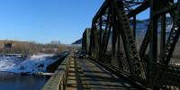
The Kaministiqua River represents the physical border between the First Nations reserve (on the right) and the land occupied by European settlers (on the left).
Location
Lat: 48° 21' 35.61" N
Long: 90° 17' 57.3" W
Elevation: 606
Precision is: Medium. Nearby, but not to the last decimal.
Equipment
A persistent belief in myself and a Nikon CoolPix 3700 Point and Shoot digital camera.
 Tap or click the zoom icon in the bottom right corner of the picture to switch between in-page and fullscreen view