

Loading panorama viewer ...
Configuring ...
© 2006 Frank van Dam, All Rights Reserved.
Caption
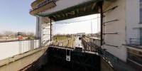
The Beatrix lock, just outside Vreeswijk, is a sort of border for the inland shipping between Rotterdam and Amsterdam. Between the Lek canal and the river Lek the ships must bridge a decline of 1.5 up to 5 meters, depending on the tide and season. The lock was built from 1932 to 1938.
Per month passes here ± 4000 ships with sand, gravel, oil etc.. (6.500.000 tons)
The waiting time lasts approximately 25 minutes in contrast to the old lock in the village Vreeswijk where frequently 8 hours had be waited to be able to sail further. The lock was modernised in 1998, and will be renovated this year.
Look at this site, which has been made by Ben van der Haar, one of the lock guards. (Dutch)
The FullScreen has sound !! Have Fun.
Equipment
Canon5D/Sigma 15FE/360P/PTMac/Cubic stuff
 Tap or click the zoom icon in the bottom right corner of the picture to switch between in-page and fullscreen view