
Mount Pinatubo Crater Lake
Borders of Zambales, Bataan, and Pampanga in the Philippines
March 18, 2006

Loading panorama viewer ...
Configuring ...
© 2006 Fung Yu,
Some Rights Reserved.

Caption
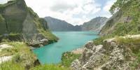
A volcano, standing on the "border" of creation and destruction.Mount Pinatubo is located on the island of Luzon in the Philippines. It is an active volcano that had a cataclysmic eruption on June 1991; after nearly 500 years of dormancy.
This view is of the present crater lake, formed from accumulated water ever since after the eruption. It has become a tourist attraction.
To get to the crater lake, you can either drive to Clark in Pampanga via the picturesque North Luzon Expressway, a leisurely 1.5 hours from the capital of Manila. Upon exiting the Expressway, you take the well paved road to the small village of Sta. Juliana. From there, numerous 4 x 4 jeeps can be hired to take you from the village up to the trek site. After a little over an hour of driving across ash-strewed moon-like terrain (with spectacular mountains on all sides just after sunrise), you start your trek on foot.
The landscape is majority of flat terrain, with flowing streams of water and low-laying vegetations. The air is cool and fresh with plenty of sunshine all throughout the day. Upon reaching the last quarter of the trek, you will go thru some dense canopy, with a small waterfall coming from the mountains (here you can refill your bottled water) before finally reaching the breath-taking view of the crater lake. The trek by foot generally takes about 3 hours.
For further reading: http://en.wikipedia.org/wiki/Pinatubo
Additional VRs upcoming at: http://www.firefly.ph
Location
Lat: 15° 6' 59.4" N
Long: 120° 21' 32.4" E
Elevation: 1,486 Meters
Precision is: Unknown / Undeclared.
 Tap or click the zoom icon in the bottom right corner of the picture to switch between in-page and fullscreen view