

Loading panorama viewer ...
Configuring ...
© 2006 Gabi Haindl, All Rights Reserved.
Caption
Saalburg Fortis part of the former border of the Roman Empire, the Limes. The Latin word limes means path or boundary. The part of the Limes here in Taunus is the Upper German-Raetian Limes.
In 1897, under Kaiser Willhlem II, the fort was reconstructed. It is the only fort that has been rebuilt and is now a museum about the Limes and a research institute is located there too.
The original fort was build around 90 AD. The Roman-Germanic border was 100 meters further north. A reconstruction of the wooden piles with a moat behind can be seen there nowadays.
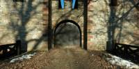
My panorama shows the western side of the Fort. It looked much more attractive in the sunset than the main entrance where all the tourists are.
More panoramas about the theme Borders.
For contact information and more panoramas of Germany, check my personal website, Kugelblick.de.
Equipment
Coolpix 5000 with the fisheye FC-E8 set to full frame, Manfrotto QTVR Kit 302+, stiched with PTMac / MakeCubic, Nadir inserted with PaintShopPro on a PC.
Caption in German
Kastell Saalburgist Teil der ehemaligen Grenze des Römischen Reichs, dem Limes. Das lateinische Wort limes bedeutet Weg oder Grenze. Dieser Teil des Limes im Taunus ist der Obergermanisch-Raetische Limes.
Kaiser Willhelm II ließ das Kastell 1897 rekonstruieren. Es ist das einzige Kastell, das wieder aufgebaut wurde. Heute ist es ein Museum über den Limes und beherbergt auch ein Forschungsinstitut.
Das ursprüngliche Kastell wurde um 90 AD gebaut. Die römisch-germanische Grenze verlief 100 Meter nödlich. Dort steht ein kurzes Stück der rekonstruierten Grenzanlage mit einer hölzernen Palisade und einem Graben dahinter.
Mein Panorama zeigt die westliche Seite des Kastells. Im Sonnenuntergang sah das viel attraktiver aus, als der Haupteingang mit all den Touristen.
 Tap or click the zoom icon in the bottom right corner of the picture to switch between in-page and fullscreen view