

Loading panorama viewer ...
Configuring ...
© 2006 James Gentles & Scott Ferguson, All Rights Reserved.
Caption
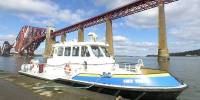
Taken from the Hawes Pier, depending on the tide part of the land or the sea. The Firth of Forth (a sea inlet on Scotland's east coast near Edinburgh) creates a border between The Lothians and the "Kingdom of Fife". For over 800 years a narrows in the estuary has been a border, a boundary and more recently a crossing point. Named "Queensferry" from Queen Margaret who crossed here in the 11th century between the ancient and modern capitals of Scotland (Dunfermline and Edinburgh). Then a dangerous one or two day journey, now 20 minutes by train, but more later...
At the top of the pier is the Hawes Inn, a hostelry since the 17th century. Robert Louis Stevenson wrote about the Inn in his novel 'Kidnapped'.
As well as two bustling towns (North and South Queensferry), the narrow sea boundary is crossed by two great bridges epitomising the 19th and 20th centuries. To the right the pinnacle of Victorian engineering carries the main railway north. When completed in 1890 its span was over 3 times longer than any other bridge in the world. The bridge was featured in Alfred Hitchcock's "The 39 Steps", an adaptation of the book by John Buchan.
On the left the suspension bridge that opened in September 1964, and replaced the car ferry service from this pier. Local debate continues regarding proposals for a third (caternary) bridge for this new century.
Location
Lat: 55° 59' 29.5" N
Long: 4° 24' 8.9" W
Elevation: 0
Precision is: High. Pinpoints the exact spot.
Equipment
Nikon 8400 with FC-E9 Fisheye. Home made pano-head.
 Tap or click the zoom icon in the bottom right corner of the picture to switch between in-page and fullscreen view