

Loading panorama viewer ...
Configuring ...
© 2006 Jerzy Zamora, All Rights Reserved.
Caption
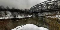
The Rivers Czarna Przemsza and Biała Przemsza create the Przemsza River - in this place, many years ago, connected three borders of partitions of Poland.
Partitions of Poland
Location
Lat: 50° 13' 49" N
Long: 19° 9' 24" E
Precision is: Medium. Nearby, but not to the last decimal.
Equipment
Canon A40 / selfmade pan head / Hugin
 Tap or click the zoom icon in the bottom right corner of the picture to switch between in-page and fullscreen view