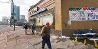

Central de Autobuses Americanos
2147 North Broadway, Denver, Colorado, USA
March 21, 2006 10:14 AM Local Time

Loading panorama viewer ...
Configuring ...
© 2006 John Fellers, All Rights Reserved.
Caption
BroadwayThis historic portion of Broadway fits into the ‘Borders’ theme on several different levels.
In 1864 Broadway was the eastern border of the congressional grant which set aside 960 acres for the original Denver settlement (at $1.25 per acre.) Incidentally, 1864 was the same year as Colorado’s infamous ‘Sand Creek Massacre,’ but that is another story.
Broadway runs north and south and serves as the border between east and west in Denver. Addresses are given an additional ‘E’ or ‘W’ designation depending on which side of Broadway they are on.
The Autobuses Americanos Station at 2147 N. Broadway provides daily bus service from Denver to many cities in Mexico. This humble, somewhat decayed building, is a symbolic border between north and south for many Hispanic, and other, travelers; both legal and illegal.
In a way this entire neighborhood; peppered with its storefront immigrant legal offices, and the Colorado Coalition for the Homeless, is a border between basic survival and a decent living — a living represented by the hazy tall modern skyscrapers—a few blocks south on Broadway.
Location
Lat: 39° 45' 6.4" N
Long: 105° 60' 15.25" W
Elevation: 5216
Precision is: High. Pinpoints the exact spot.
Equipment
Nikon D100, Sigma 8mm, Bogen 302, Adobe Photoshop CS, PTtools GUI and PanoCubeFor my semi-original composition/performance of the 30 sec blues: '79 Strat, Peavey Bass, Blues Harp in A and a rhythm egg. (Behringer Eurorack MX 604 4 channel mixer, Acoustic Labs Multitrack Recorder 3 and an ancient copy of Sound Forge 4)
 Tap or click the zoom icon in the bottom right corner of the picture to switch between in-page and fullscreen view