

Loading panorama viewer ...
Configuring ...
© 2006 John Law, All Rights Reserved.
Caption
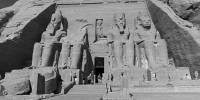
The Temple of Rameses II and Lake Nasser - Abu Simbel - Upper Egypt.Built during the reign of Rameses II (1279-1213 bce) to mark the southern boundary of Egypt. The site of this temple was submerged by the creation of Lake Nasser behind the new High Dam, built with Soviet aid 1960-71 at Aswan.
This temple and the adjoining temple to Queen Nefertari were hand-sawn into numbered pieces, moved up a cliff and reassembled in an artificial hill.
The High Dam allows Egypt to control the Nile to irrigate crops for 3 harvests a year, to further irrigate large areas of desert (the Toshka Project and others) and to generate hydro-electricity to support its growing industry.
Equipment
Nikon D70/10.5 lens/360p head
PTMac/PS CS2/ Cubic Converter
 Tap or click the zoom icon in the bottom right corner of the picture to switch between in-page and fullscreen view