

Loading panorama viewer ...
Configuring ...
© 2006 John Wilson, All Rights Reserved.
Caption
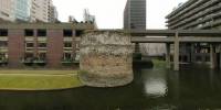
London Wall was built by the Romans around the year 200 AD to form a defensive border around Londinium, the ancient Roman name for London, UK.The wall was built mostly from Kentish ragstone and was 5 m high and 2 to 3 m wide, including a number of bastions, enclosing an area of approximately 330 acres (1.3 square km).
The panorama shows one of the best-preserved remaining bastions at the Barbican Estate in the City of London, now surrounded by some of the tallest residential buildings in the UK.
Equipment
Nikon Coolpix 5000, FC-E8 fisheye, Manfrotto MN 302 Plus VR head, PTMac, CubicConverter, Photoshop
 Tap or click the zoom icon in the bottom right corner of the picture to switch between in-page and fullscreen view