

Loading panorama viewer ...
Configuring ...
© 2006 Kaz George, All Rights Reserved.
Caption
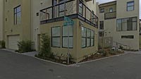
This panorama was taken in Emeryville CA, several meters from the Emeryville-Oakland border. The subject was a new condominium development with a private driveway, City Limits Circle, which loops around the center of the complex to converge with itself at the entrance/exit. My tripod was set up in the middle of the intersection of City Limits and City Limits, and the mildly cynically amusing street-sign is the focus of my picture. To add to the inherent sarcasm of the situation, the large orange industrial building seen directly through the complex entrance is in three separate cities, Oakland, Emeryville and Berkeley.The photography for this panorama was complicated by the weather that day, which was extremely erratic. In a five-minute period, it would go from bright and sunny to extremely cloudy so that I would have to worry about both blowing out my light colors and deep shadows. Before I processed this panorama, the pictures were extremely dark (not only due to the clouds over the sun, but also because I was in the enclosed condominium with high walls), and it took a fair amount of lightening in Photoshop. Overall, I think that the image quality was good, the picture was very aesthetically pleasing, and my panorama fit the theme very well, so I am happy with it.
Location
Lat: 37° 51' 4" N
Long: 123° 18' 17" W
Elevation: 12 meters
Precision is: High. Pinpoints the exact spot.
Equipment
Photographed with an Olympus E-500 camera with a 14-54mm lens at 14mm (28mm equivalent), mounted on a Kaidan QuickPan III, Velbon tripod and Acratech ball head. Stitched with QuickTime VR Authoring Studio, post-processing with Adobe Photoshop CS.
 Tap or click the zoom icon in the bottom right corner of the picture to switch between in-page and fullscreen view