
Noeveren/Hellegat
Noeveren/Hellegat, Boom/Niel, Flanders, Belgium
March 19, 2006 - around 2pm

Loading panorama viewer ...
Configuring ...
© 2006 Koen Verschaeren,
Some Rights Reserved.

Caption
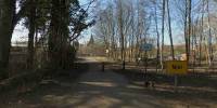
I didn't have much time so it's a location close to home.This is the official border between Noeveren and Hellegat.
Noeveren is part of a city called Boom. Hellegat is part of another village: Niel.
It's a very logical and natural border because it's a small stream.
Technically this panorama is not perfect. It was very difficult to compress. I think because of the small details in the trees. This is clearly visible in the small version.
I blended 2 exposures (2 stops difference) to compensate for the huge contrast because of the sun which is still rather low this time of year.
Equipment
D7010.5mm
360P
PTGui
CubicConverter
 Tap or click the zoom icon in the bottom right corner of the picture to switch between in-page and fullscreen view