

Loading panorama viewer ...
Configuring ...
© 2006 Piotr Popik, All Rights Reserved.
Caption
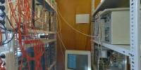
This is the current border of computational abilities at the Department of Medicinal Chemistry, Institute of Pharmacology, Polish Academy of Sciences in Krakow, Poland. Receptor modeling helps predict if the novel compound can be a potential drug candidate. However, calculating the interactions among molecules constituting the receptor requires a lot of computer power, which is made possible by building supercomputers.
Nowadays, you do not need Cray computer for this: one can built such a supercomputer joining together a pool of regular PC's on a very fast network. Here, 16 PCs running Linux work orchestrated for weeks to resolve incredibly difficult set of equations. Chemists are expected to model 5-HT7 serotonin receptor and use it to design novel medicines.
Equipment
The panorama was taken with Peleng MC f 3.5/8 mm lens (set at f 8, ~ 0.5 m) on Canon EOS 20D camera, (set at 1/4s, ISO 200). The panorama was stitched with 5 images (4 around plus zenith) using Professor’s Helmut Dersch Panorama Tools (PTGui 4.1 graphical interface). Autopano and Enblend, as well as Gimp's ability to create Text Circle Logo were all of great help. I used 8 bit source images. Equi-rectangular image was converted to QT with free version of Pano2QTVR.
 Tap or click the zoom icon in the bottom right corner of the picture to switch between in-page and fullscreen view