

Loading panorama viewer ...
Configuring ...
© 2006 Romuald Vareuse, All Rights Reserved.
Caption
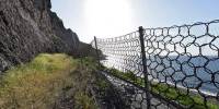
Road protection against falling rocks.
48 hours after this panography have been made, 30.000 square-meters of rock felt on a road, 30 km away, killing two people. We cannot choose to live with only the good sides of Nature.
Location
Lat: 21° 52' 15" S
Long: 55° 14' 40" E
Elevation: 60m
Precision is: Medium. Nearby, but not to the last decimal.
Equipment
Canon 1dsmk2, fe 15mm, 360p, ptmac
 Tap or click the zoom icon in the bottom right corner of the picture to switch between in-page and fullscreen view