

Loading panorama viewer ...
Configuring ...
© 2007 Jean Berthélémé, All Rights Reserved.
Caption
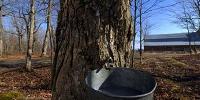
Rocky Mountain Maples is a "sugar camp" (also known as a "sugarbush") and from mid-March to mid-April the atmosphere here changes as the owners get busy preparing the trees, collecting and boiling the sap, producing sweet maple products and welcoming customers to the camp. The atmosphere here, at this time of the year, is that of quiet awakening as nature and people welcome the change of seasons. A noticeable change in the atmosphere can be seen as winter gradually relents and spring brings warmer temperatures. The ideal atmospheric conditions for collecting maple tree sap are freezing nights and daytime temperatures of about 5 to 6 degrees Celcius (41-43 degrees Fahrenheit). Speaking of atmosphere, the boiling process produces lots water vapour which escapes into the atmosphere in white billowing clouds (unfortunately, on this day no boiling was done). At Rocky Mountain Maples, sap is collected in the traditional way, in a bucket attached to a small metal tube inserted into the trunk of the tree. Maple trees, in particular a variety called sugar maple, have a sweet tasting sap which can be concentrated by boiling. Almost every day, large containers of sap are heated by wood-fired stoves. The result is a very sweet syrup which can then be further transformed into hard candy and hard or soft cream.
Approximately 40 litres of sap are required to produce one litre of maple syrup (one litre = .26 US gallon). A mature sugar maple tree can produce about 40 litres of sap during the 4-5 week season; only trees with a diameter of about 25 centimetres (10 inches) are tapped.
Canada produces more than 80% of the world's maple syrup; most of the production is concentrated in the provinces of Quebec, Ontario and New Brunswick. A handful of north-eastern US states also produce maple products.
Location
USA-Canada / Canada-New Brunswick
Lat: 46° 10' 5.16" N
Long: 65° 52' 42.84" W
Precision is: Unknown / Undeclared.
Equipment
I used a 12 mm lens on a digital SLR camera rotated on a custom-made panoramic head placed on a tripod. Eight vertical images were captured in RAW format, colour-corrected, converted to TIF format, then stitched, sharpened and saved as a QuickTime QTVR file. Angle of view is almost 90(v) by a full 360(h) degrees. The source panoramic image is over 35 megapixels in size but must be reduced for on-screen delivery.
 Tap or click the zoom icon in the bottom right corner of the picture to switch between in-page and fullscreen view