
Land Use Diversity
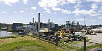
Petaluma River, Petaluma, California, USA
March 22, 2009, 16:35 PDT

Loading panorama viewer ...
Configuring ...
© 2009 Landis Bennett, All Rights Reserved.
Caption
The Petaluma River has long been a very busy "working river." It's been used to ship eggs and other local products to San Francisco and to rail yards in the East Bay to be shipped all over the country. After the Great Quake of 1906 many of the materials to rebuild San Francisco came through Petaluma. Now the river is still a working river with several businesses using it every day. But it also has other industrial buildings surrounding it as well as newer apartment and office buildings. The land use patterns for the area are changing, but they are much more diverse now than they've been in the past.
360Geographics - Panoramas from all over North America of tourist destinations and places off the beaten path.
Equipment
Hardware: Nikon D200, Nikkor 10.5mm Lens, Kaidan QuickPan III SpehericalSoftware: PTGui/Mac, Photoshop CS3, CubicConverter
 Tap or click the zoom icon in the bottom right corner of the picture to switch between in-page and fullscreen view