

Loading panorama viewer ...
Configuring ...
© 2009 Piotr Popik, All Rights Reserved.
Caption
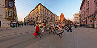
This shows one of the most popular places in downtown Cracow, very close to the Old Market. Taken in the very rare (this season) sunny afternoon.Marianna is 2 years and 9 months old.
Equipment
The panorama was taken with Peleng MC f 3.5/8 mm lens (set at f 8, ~ 1.5 m) on Canon EOS 20D camera, (set at: 1/60 - 1/125), ISO 200). The panorama was stitched with 7 images (5 around plus nadir and zenith) using Professor’s Helmut Dersch Panorama Tools (PTGui 4.1 graphical interface). Autopano and Enblend, as well as Gimp's ability to create Text Circle Logo were all of great help. I used 8-bit source images. The equirectangular image was converted to Quicktime with a registered version 1.6.2 of Pano2QTVR Pro.
 Tap or click the zoom icon in the bottom right corner of the picture to switch between in-page and fullscreen view