

Loading panorama viewer ...
Configuring ...
© 2010 Piotr Popik, All Rights Reserved.
Caption
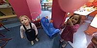
This was the 4th birthday party of Ola (with the balloon), a Kindergarten friend of our Marianna (showing her tongue). Kulkoland is the place that we have been visiting frequently, and it significantly contributed to the motor development of our baby.As to the food: I tried the cake, and it was OK.
See more here
Location
Lat: 50° 1' 15.18" N
Long: 19° 54' 10.42" E
Precision is: Medium. Nearby, but not to the last decimal.
Equipment
The panorama was taken with Peleng MC f 3.5/8 mm lens (set at f 8, ~ 1.5 m) on Canon EOS 20D camera, (set at: 1/60), ISO 800). The panorama was stitched with 5 images (4 around plus nadir) using Professor’s Helmut Dersch Panorama Tools (PTGui 4.1 graphical interface). Autopano and Enblend, as well as Gimp's ability to create Text Circle Logo were all of great help. I used 8 bit source images. Equi-rectangular image was created with registered version 1.6.2 of Pano2QTVR pro.
 Tap or click the zoom icon in the bottom right corner of the picture to switch between in-page and fullscreen view