

Loading panorama viewer ...
Configuring ...
© 2011 Piotr Popik, All Rights Reserved.
Caption
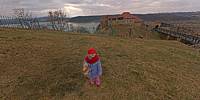
According to Wikipedia, Dobczyce is a town in southern Poland, situated in the Lesser Poland Voivodeship. There is a large dam on the river Raba and a partially rebuilt 14th century castle, which is open for tourists.It could be a perfect place for shooting WWP panorama if the weather would be pleasant, which was not the case... +4 Celsius and strong wind took all the pleasure out of us. Well, maybe next time!
Equipment
The panorama was taken with a Peleng MC f 3.5/8 mm lens (set at f 8, ~ 1.5 m) on Canon EOS 20D camera, (set at: 1/250, ISO 200). The panorama was stitched with 5 images (4 around plus nadir) using Professor’s Helmut Dersch Panorama Tools (PTGui 4.1 graphical interface). Autopano and Enblend, as well as GIMP's ability to create the Text Circle Logo were all of great help. I used 16-bit source images.
The equirectangular image was created with a registered version of Pano2QTVR Pro 1.6.2.
 Tap or click the zoom icon in the bottom right corner of the picture to switch between in-page and fullscreen view