

Loading panorama viewer ...
Configuring ...
© 2004 Kenneth P. Stuart, All Rights Reserved.
Caption
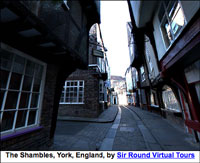
Although not a World Heritage site, most of the buildings in The Shambles date to the 15th-17th Centuries. The street takes its name from the small "shammel" benches facing the street. Butchers would lay their meats on the shammels for shoppers to inspect. No doubt the smells of the area in times past would be offensive to us, as the area was infamous for its poor sanitation. The Shambles is the only existing street from medieval York to have been mentioned in the Domesday Book of the late 11th Century.
Equipment
Panoscan/16 mm
 Tap or click the zoom icon in the bottom right corner of the picture to switch between in-page and fullscreen view