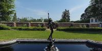

Formal Garden, King's Garden, Fort Ticonderoga
Ticonderoga, New York, USA
June 23, 2006

Loading panorama viewer ...
Configuring ...
© 2006 Carlton SooHoo, Ph.D., All Rights Reserved.
Caption
A Brief History of Fort Ticonderoga is provided at:
http://www.fort-ticonderoga.org/history/brief_history.htm Fort Ticonderoga was built by the French from 1755-1758 as Fort Carillon located above the narrow choke-point between Lake Champlain and Lake George, which controlled the major north-south inland water "highway" during the 18th century. Due to this strategic location the Fort was the "key to the continent" as the superpowers of the 18th century, the French and the British, contested for empire in North America. On July 8, 1758 the Fort was successfully defended by French forces under the command of the Marquis de Montcalm despite overwhelming British forces led by General Abercromby. This was France's greatest victory in the Seven Years' War and a humiliating and devastating defeat for the British. The following year, the British did defeat the French at Fort Carillon under General Amherst who renamed the site Fort Ticonderoga.
At the outset of the American Revolution just a half-company of British soldiers manned the Fort. On May 10, 1775, Ethan Allen, Benedict Arnold, and the Green Mountain Boys crossed Lake Champlain from Vermont under cover of darkness. At dawn they surprised the sleeping garrison and overwhelmed them, making Fort Ticonderoga America's first offensive victory of the Revolutionary War. From then until July 1777, Fort Ticonderoga served as an important staging area for the American army while fortifying Mount Independence in Vermont and building extensive defensive works within a 10-mile radius. In addition, the Fort was where vessels for America's first navy were rigged and fitted out. This fleet, under the command of Benedict Arnold, fought the Battle of Valcour Island on Lake Champlain in 1776. Although the American fleet was utterly defeated, the fight stalled the British on their march south. The following year, in July 1777 the British commander, General Burgoyne, invaded the Champlain Valley from Canada and managed to place cannon on Mount Defiance overlooking Fort Ticonderoga. This forced the Fort's American commander, General Arthur St. Clair to evacuate his army on July 6th, handing the Fort back to the British. The last military engagement at the Fort occurred in September 1777 when Americans failed to attempt to retake the Fort.
In 1820, William Ferris Pell purchased the ruins of the Fort and the surrounding land to preserve it for posterity. In 1826 he built home overlooking Lake Champlain, which he later turned into The Pavilion, a hotel to serve the growing number of tourists who came to see the Fort ruins. In 1908 Stephen and Sarah Gibbs Thompson Pell began restoration of Fort Ticonderoga and in 1909 it was opened to the public with President Taft in attendance. In 1931 Fort Ticonderoga was designated a not-for-profit educational historic site managed by the Fort Ticonderoga Association.
Henry Knox hauls Sixty tons of artillery (59 cannon and mortars) from Crown Point and Fort Ticonderoga to Cambridge, Massachusetts http://www.fort-ticonderoga.org/history/bibliographies/henry_knox.htm
The Knox Cannon Trail describes the route that Henry Knox took from Fort Ti to Cambridge, MA. http://www.nysm.nysed.gov/services/KnoxTrail/kthistory.html
Route ran from Fort Ticonderoga to Lake George "down the west bank of the Hudson as far as Albany, then to cross the river and down the east Bank as far as Kinderhook, from whence to turn due east across the Berkshires, through Great Barrington, Monterey, Otis, Blandford, Westfield, Springfield, and so to Cambridge." (The route from Fort Ticonderoga to the Massachusetts state line has been traced with 30 granite historical markers, installed by the state of New York in the late 1920s. The inventory of 30 historical markers placed along the Massachusetts portion of the route is found in Fiore and Schruth, Noble Train, p. 54.)
Five markers are in Ticonderoga area: (#1) Fort Place d’Armes; (#2) dock near King’s Store where the cannon were loaded onto a gundaloe on 6 December 1775 "to get them to the bridge"; (#3) near Lower Falls in Ticonderoga village, where the cannon were transferred from water to land carriage, "from the bridge to the landing at Lake George" on 7 December; (#4) near Mossey Point at Lake George where Knox had loaded "the scow, Pettianger, and a Battoe" by 9 December; (#5) Sabbathday Point.
Arrival in Cambridge 24 January 1776; 300 miles in two months.
Memorial granite markers showing the route were placed in the summer of 1927. The Bulletin of the Fort Ticonderoga Museum, vol. I no. 2 (July 1927), pp. 1.
The significance of the event is that these cannons were placed on Dorchester Heights, overlooking the British fleet in Boston Harbor. The British soldiers woke up to artillery aimed directly at them and realized that they had to evacuate Boston. March 17 is celebrated each year as the "evacuation day". This was the first victory for the newly appointed General George Washington.
This panorama is part of the Virtual American Revolution project.
Location
Lat: 43° 51' 14" N
Long: 74° 24' 8" W
Precision is: Medium. Nearby, but not to the last decimal.
Equipment
Fujifilm Finepix S3 Pro camera, Nikkor 8 mm f/2.8 fisheye lens, Agnos MRotator TCP panoramic tripod head, Panoweaver for stitching, Adobe CS2 for retouching.
 Tap or click the zoom icon in the bottom right corner of the picture to switch between in-page and fullscreen view