

Loading panorama viewer ...
Configuring ...
© 2006 Peter Werner, All Rights Reserved.
Caption
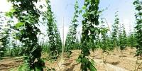
Hop is grown here.The panorama is taken in an hopgarden at Hallertau.
Halltertau (also called Holledau) is a region in Bavaria
and the biggest hop-planting area in the world.
for more information see wikipedia: hop (english), Hallertau (german)
Location
Lat: 48° 33' 36" N
Long: 11° 41' 19" E
Precision is: Medium. Nearby, but not to the last decimal.
Equipment
coolpix 4500, fc-e8
 Tap or click the zoom icon in the bottom right corner of the picture to switch between in-page and fullscreen view