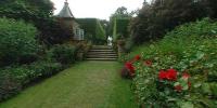

The Red Borders, Hidcote Manor Garden
Near Chipping Campden, Gloucestershire, England, UK
June 24, 2006 - 15:21 UTC (16:21 Local Time)

Loading panorama viewer ...
Configuring ...
© 2006 Robert Bilsland, All Rights Reserved.
Caption
Here in England we are spoilt for choice with lots of great gardens, big or small, private or public. We also have the National Trust, a charity that protects and has open to the public over 300 historic houses and gardens. My family and I are members of the National Trust and go around visiting properties where we can, sometimes local to home, sometime while on holiday. It doesn't mean you can't visit the properties if you not a member, but you do have to pay an entrance fee each time.While trying to choose what garden to shoot, I came up with visiting a National Trust property and Hidcote Manor Garden. The garden was created by Lawrence Johnston and the description of "a series of outdoor rooms each with its own unique character" made me want to visit it. Luckily the weather was with me on the day and I had glorious sunshine and blue skies. I started off with the idea of shooting a few and then choosing the best, but when I got there it was soon clear that a few wouldn't be enough, the description had been right.
At the end of the day I had shot 14 panoramas and still not captured everything there, but enough to capture the style of the place. You could be walking around a small pond, through a hedge and you're on a long green lawn, up some steps and you're looking down at a walkway of red flowers. You can see the panoramas I shot in list form here or arranged as a small virtual tour here. On top of these you can find more that I shot at other National Trust properties here. Once on the page just select one of the properties listed on the left.
The National Trust site;
http://www.nationaltrust.org.uk
Hidcote Manor Garden on the National Trust site;
http://www.nationaltrust.org.uk/main/w-vh/w-visits/w-findaplace/w-hidcotemanorgarden/
My Hidcote Manor Graden Panoramas;
http://panoramasunlimited.com/content/view/58/160/
My VR Tour around Hidcote Manor Garden;
http://panoramasunlimited.com/content/view/59/161/
All of my National Trust panoramas;
http://panoramasunlimited.com/content/view/25/162/
Location
Lat: 52° 5' 1.58" N
Long: 2° 45' 43.17" W
Elevation: 627 ft
Precision is: High. Pinpoints the exact spot.
Equipment
Taken with a Nikon Coolpix 990 and a FC-E8 Fisheye lens. Mounted on a simple L shaped bracket. 4 portrait frames taken 90 degrees apart with the fisheye circle just touching the top and bottom of the frame, while being clipped on the left and right. Stitched using PTGui / Panotools and converted to a QTVR Cube using Pano2QTVR Pro.
 Tap or click the zoom icon in the bottom right corner of the picture to switch between in-page and fullscreen view