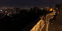

The Mountain (yes, with a capital M)
Montreal, Québec, Canada
June, 22, 2008 - 10:01 PM Local Time

Loading panorama viewer ...
Configuring ...
© 2008 Eduardo Hutter, All Rights Reserved.
Caption
Being born and grown-up in a city like Rio de Janeiro where majestic mountains raise over 1000 meters high, with vertical big-bare-rock-walls stretching up to 600 meters right in the middle of the city, I couldn't help it and to the dismay of my mother, I turned out to be a rock-climber.Now, eight thousand kilometers distant, two children and twenty-something years later (ten of these living in Québec), I still find the Mount Royal rather boring on its geography. It's just 233 meters, gentle slopes that are good for a Sunday evening walk with grandma but like most Montrealers do, now I feel somewhat proud of our little, err... lets say... bump on the landscape so, we use to call it "the mountain" with a capital M (as if it could help and make it bigger).
A bit of history about it: Long before the establishing of the first catholic cemetery at fort Ville-Marie, which centuries later would become the city of Montreal, French navigator and explorer Jacques Cartier climbed the Mount Royal, naming it in honor of François I, king of France.
Today, the Mountain is the site for one of Montreal's largest greenspaces officially know as Parc du Mont Royal. Inaugurated in 1876, the park was originally designed by Frederick Law Olmsted, whom also designed New York's Central Park.
Uh? What did I just say? That Jacques Cartier climbed it? Go figure...
http://www.Montreal360.ca - more panoramas about Montreal and its surroundings
Equipment
Hard: Nikon D200; Nikkor 10.5mm f/2.8 and Nodal Ninja 3.Soft: PTGui 7.2; Photoshop CS2 and Pano2QTVR 1.6.6 Pro.
 Tap or click the zoom icon in the bottom right corner of the picture to switch between in-page and fullscreen view