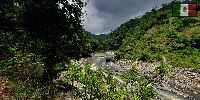

The North Sierra - Lajajalpan River
Zacatlan de las Manzanas, Puebla State, Mexico
June 22, 2008 - 13:57 Local Time

Loading panorama viewer ...
Configuring ...
© 2008 Roberto Gómez Torres, All Rights Reserved.
Caption
ENGLISH TEXTThe Elevation Theme
In order to contribute to this new World Wide Panorama event I made a trip to the mountains. On this opportunity my friends and I organized to camp at the North Sierra in the State of Puebla. Here elevation is everywhere with at least with 2,000 m. above sea level with lots of glens, hills, rivers going down, small and medium waterfalls, mountains and clouds going up and down with the change of the wind, the weather or the passage of the hours.The Panorama
Our base camp was set at the outer area of the Zacatlan de las Manzanas town. At that place The glen of the linnets starts to go down. A long hike is needed to arrive at the bottom and reach the Lajajalpan river which crosses all the North Sierra. The road down to the river is beautiful, traversing a nice forest for around two and a half hours.After following the river for about two or three kilometers I choose this spot were the river forms a nice serpent figure.
Hope you like the view !!!
TEXTO EN ESPAÑOL
El Tema: Elevación
Para formar parte de este nuevo evento del World Wide Panorama realicé un viaje a las montañas. En esta oportunidad mis amigos y yo organizamos salir de campamento a la Sierra Norte en el Estado de Puebla. En este lugar el tema elevación se puede ver por todos lados. Estando a una altura mínima de 2,000 m. sobre el nivel del mar encontramos múltiples cañadas, cerros, ríos, pequeñas y medianas cascadas, montañas y nubes subiendo o bajando con el cambio de los vientos, del clima o tan solo con el paso de las horas del día.El Panorama
Nuestro campamento base lo instalamos a las afueras del pueblo de Zacatlán de las Manzanas. En ese punto desde lo alto comienza a caer La Barranca de los Jilgueros. Una larga caminata por senderos es necesaria para llegar al fondo de la misma cañada y encontrar el río Lajajalpan, el cual cruza la Sierra Norte. El camino abajo para llegar al río es hermoso, durante un espacio de dos horas y media se cruza un bosque poblado por árboles de pino y grandes ocotes.Después de haber seguido el cauce del río por dos o tres kilómetros escogí tomar el panorama en este punto donde el río serpentea y deja ver su forma caprichosa desde lo alto de una colina.
¡ Espero les agrade esta vista panorámica !
Tiempo Digital - Multimedia Analysis, Design and Development
Location
Lat: 19° 55' 36.48" N
Long: 98° 57' 21.26" W
Elevation: 2,029 m.
Precision is: High. Pinpoints the exact spot.
Equipment
Taken with a Nikon D300 Single Lens Reflex (SLR) digital camera and the Nikon 10.5mm F/2.8 full frame fisheye lens. Mounted on a "Really Right Stuff" panoramic head. Stitched using Nikon Capture NX, Enfuse, PTGui Pro v.7.8 and Adobe Photoshop CS2 under Microsoft Windows XP Professional. Self made Windows software "Quicky Pano" for QuickTime VR conversion.
 Tap or click the zoom icon in the bottom right corner of the picture to switch between in-page and fullscreen view