

Loading panorama viewer ...
Configuring ...
© 2008 Rolf Ris, All Rights Reserved.
Caption
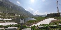
St. Gotthard divides Europe:Elevation 2091 m
St. Gotthard divides Europe in different cases:
Water division
The Gotthard moutain formation is also called the continental water divide of Europe.
From that the "Rhine" flows down to the North Sea, the "Rhone" flows to the Mediterranean Sea, the "Ticino" flows into the "PO" and in the Adriatic Sea, the "Inn" flows into the "Donau" down to the Black Sea.
Weather division
Often in Europe (and more locally in Switzerland) we have two different weather conditions.
When there is rainy weather north of St. Gotthard, it is then mostly that we have warm and sunny conditions in the south.
But it also connects Europe.
It is one of the most important passes in the Alps. Because of the tunnels for cars and trains, most of the people at the elevation of 2091 m are tourists now. If you are interested, click for more details on the links below:
Infos:
Wikipedia - german page
Wikipedia - english page
Location
Lat: 46° 33' 21.36" N
Long: 8° 34' 2.93" E
Elevation: 2091
Precision is: Unknown / Undeclared.
Equipment
Nikon D300 - Nikkor 10,5 (fullframe fisheye) Manfrotto 055ProB with NodalNinja 3
PtGuiMac - Photoshop - CubicConverter
Quicktime Pro
Macintosh Powerbook 17" - 1,67 GHz OSX 10.5
 Tap or click the zoom icon in the bottom right corner of the picture to switch between in-page and fullscreen view