
Sauratown Mountain
Stokes County, North Carolina, USA
Friday, June 20, 2008. 6:30 p.m. local time (-4 GMT)

Loading panorama viewer ...
Configuring ...
© 2008 Tom Lassiter, All Rights Reserved.
Caption
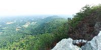
Sauratown Mountain, populated with mobile phone, television and radio towers, stands about 30 miles north of Winston-Salem. On a crisp fall day, the city's high-rise buildings would be visible, as well as those of Greensboro, about 55 miles distant. But not in summer's haze.At the foot of the mountain is Camp Hanes, a YMCA camp where my two sons and I spent many adventure-filled weekends with the Y Guides.
Sauratown Mountain is named for the Saura, a tribe of Native Americans who lived in this region for centuries before Fernando DeSoto arrived in 1540 and noted their presence in his journals.
This small peak sits between Pilot Mountain to the west (not visible in the panorama) and Hanging Rock to the east. Hanging Rock – the dominant, dual-peak ridge in the distance – and Pilot Mountain are state parks. For the geologists reading this, the peaks are quartzite monadnocks.
Sauratown Mountain once had an active hang gliding club, but flights ended some years ago. Today the decaying launch ramp is all that remains.
Now the crest of the peak is off limits to the public ... unless you are a stealthy pano photographer with a long pole.
History of the Saura: http://www.visitstokesnc.com/Default.aspx?tabid=55
More Westridge VR panoramas: http://www.lassiter.com/vr/exp7.html
Location
USA-Canada / USA-North Carolina
Lat: 36° 22' 28.5" N
Long: 81° 23' 17.2" W
Elevation: 2,241 feet / 683 meters
Precision is: Unknown / Undeclared.
Equipment
Fuji S2 Pro; 8mm Sigma; Bo Bracket; extended painter's pole.Photoshop CS3, PTGui, Cubic Converter, Mac OS X.
 Tap or click the zoom icon in the bottom right corner of the picture to switch between in-page and fullscreen view